NASA is closely monitoring the unfolding of one of nature’s most powerful climate phenomena – El Niño, which is projected to reach historic proportions in 2026. This event, occurring approximately every two to seven years, is already impacting global weather by altering ocean currents, redistributing heat, and changing climate patterns. The National Oceanic and Atmospheric Administration (NOAA) has indicated an 83% probability that we are witnessing the strongest El Niño since 1950, with NASA satellites playing a crucial role in its observation.
Sea Level Changes: The Ocean in Motion
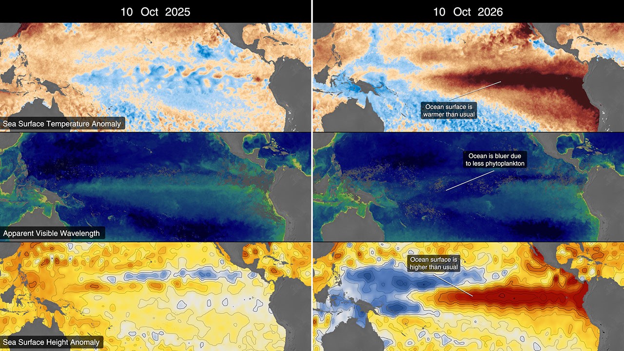
One of the early indicators of the approaching El Niño was the detection in January 2026 of a Kelvin wave, a surge of warm water, near Micronesia in the western Pacific Ocean. These slow but powerful water pulsations, spanning thousands of kilometers, transport heat from east to west, warming the air above. This, in turn, weakens or even reverses the trade winds, which typically blow from the Americas toward Asia. Consequently, sea levels rise in the eastern Pacific, and the water becomes even warmer. By mid-April 2026, these waves reached the eastern Pacific, causing a rise in sea surface temperatures. The warmer water expands, increasing local sea levels by 30-40 centimeters, while Indonesia and northern Australia experienced a sea level drop of 15-20 centimeters. The Sentinel-6 satellites, equipped with high-precision radar altimeters, measure ocean height with accuracy down to fractions of an inch, providing a continuous picture of these changes since 1993.
Warming Pacific Waters and Shifting Colors
The rise in Pacific Ocean surface temperatures is one of the most well-known El Niño indicators. Already, temperatures in the eastern Pacific are 1.7 degrees Celsius above long-term average values, and this figure could increase further. Satellites equipped with microwave and infrared radiometers can penetrate clouds to measure the ocean’s surface heat energy. In 2026, satellite data revealed an expansion of the warm water band, stretching for millions of square kilometers from the central Pacific towards the coast of South America. These warm waters influence global weather patterns, transferring heat and moisture into the atmosphere, leading to the formation of rainstorms and altering weather systems worldwide. Beyond temperature, El Niño also affects ocean color. NASA satellites are capturing how the waters of the equatorial Pacific are becoming noticeably bluer. This is linked to changes in the concentration of phytoplankton – microscopic plants that form the base of marine food webs. In areas where significant phytoplankton is usually present, giving the water a greenish hue, this indicator is decreasing, leading to a visual shift in ocean color.
Source: NASA