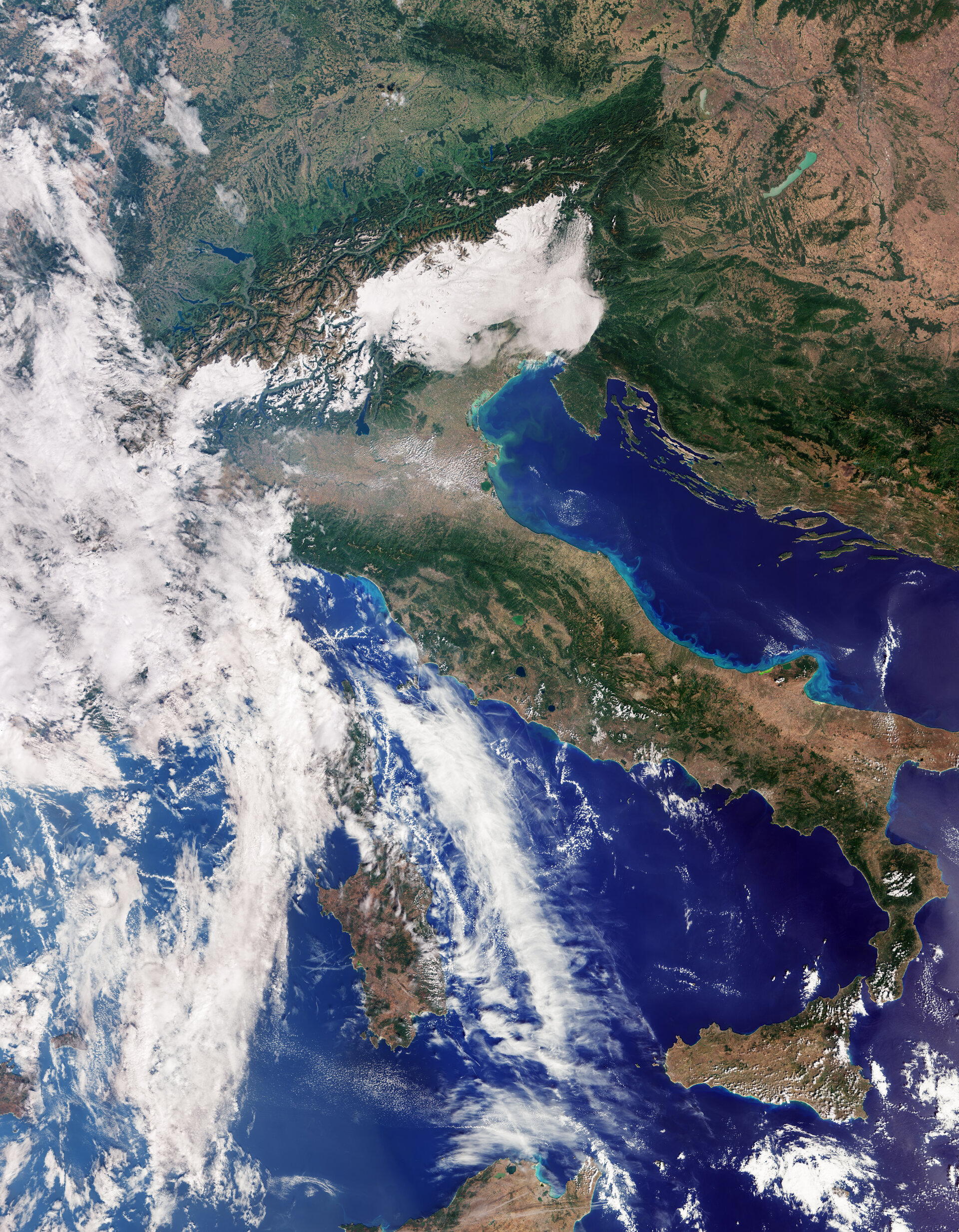
Just two weeks after its launch, the European Space Agency’s (ESA) Copernicus Sentinel-3C satellite has transmitted its first captivating images and measurements, captured by its two primary instruments. This milestone confirms the satellite’s successful operation and readiness to commence its extensive mission of monitoring Earth’s oceans, land, cryosphere, and atmosphere.
First Images: Earth’s Beauty from Orbit
Among the initial data received are striking images of Italy, the Arctic, and the Caribbean, acquired by the Ocean and Land Colour Instrument (OLCI). Additionally, the Synthetic Aperture Radar Altimeter (SRAL) has already provided measurements of the Greenland ice sheet’s height and sea surface height. Sentinel-3C is the third satellite in the Sentinel-3 series and will continue the long-term mission of delivering crucial environmental data for a wide range of applications.
These early images already showcase the satellite’s remarkable efficiency. The first image, captured on September 30th, displays Italy in true color with astonishing detail, spanning from southern Germany to Sicily and the southern Mediterranean Sea. The fertile Po River valley, the snow-capped Alps contrasting with the lowlands, and variations in vegetation and land cover across the country are clearly visible. The oceans surrounding the Italian peninsula, from the Adriatic to the Tyrrhenian Sea, also reveal their hues, indicating the presence of sediments carried by rivers.
A second image, taken the same day, features a portion of the Canadian Arctic Archipelago. Islands covered in snow and ice dominate the scene, with their rugged coastlines and deep fjords. While sea ice is at its minimum at this time of year, isolated ice floes are visible. The Arctic is warming significantly faster than the global average, leading to rapid melting of glaciers and sea ice, triggering feedback cycles that further accelerate warming.
The third snapshot, acquired on September 29th, captures a part of the Caribbean basin, with Cuba to the south and the Bahamas to the north. The shallow waters surrounding the islands stand out in beautiful turquoise against the darker waters of the open ocean. Sentinel-3C’s SRAL instrument measures sea surface height variations, which are critically important for monitoring sea-level rise, a significant threat to low-lying islands and coastal regions.
Sentinel-3C: Monitoring Earth for Science and Society
The Sentinel-3 satellites are the workhorses of the Copernicus program, equipped with an identical suite of instruments for systematic Earth observation. This data forms the basis for:
- Monitoring sea surface temperature, color, and height, as well as sea ice thickness, to detect marine pollution and heatwaves.
- Identifying droughts and forest fires, mapping land use, and assessing vegetation health.
- Measuring the height of rivers, lakes, and polar ice caps.
- Providing parameters for weather forecasting and long-term climate change monitoring.
Even during its commissioning phase, which will last another five months, the initial data from Sentinel-3C is already demonstrating its high performance. For example, a map of sea surface height measurements in the Atlantic Ocean and Mediterranean Sea, generated by the radar altimeter, shows excellent agreement with current measurements. Once fully operational, this data will complement long-term records from missions like Copernicus Sentinel-6 and Jason, helping scientists determine the rate of global sea-level rise with high accuracy (3.64 mm per year since 1999, with an accelerating trend).
An animation of Greenland ice sheet height measurements, acquired between September 30th and October 4th, also confirms the altimeter’s correct functioning. Monitoring changes in the height of the Greenland and Antarctic ice sheets is key to understanding the impacts of climate change and improving future sea-level projections, as ice loss is a primary driver of its rise.
The first data from Sentinel-3C’s sea and land surface thermometer is expected soon.